HERE Technologies’ Use of Mobile Mapping Technology
HERE Technologies’ Use of Mobile Mapping Technology Published: April 8, 2026 Category: Integrate, Collect, Map Client: HERE Technologies Share this case: Customer HERE Technologies HERE
Over 10 years we help companies reach their financial and branding goals. Engitech is a values-driven technology agency dedicated.
411 University St, Seattle, USA
engitech@oceanthemes.net
+1 -800-456-478-23
Topocart is a true market leader in the field of cartographic data acquisition in Brazil with 34 years of experience. When municipalities across Brazil demanded precise panoramic imagery for regular cadastral updates and urban infrastructure management, Topocart turned to mobile mapping to meet these needs at scale.
Clarival Paiva, Executive Manager | Topocart
the
In 2019, Topocart received service requests from various municipal administrations requiring precise location of images for a large variety of applications. These included cadastral updates and building categorization, asset management and illegal commerce identification. They needed a solution that could deliver reliable results across vast distances in Brazil’s diverse urban environments
01 High-Resolution Panoramic Imagery
Municipal clients needed detailed panoramic images to document the state of affairs and characterize buildings for cadastral updates, requiring a camera system with excellent image quality.
02 Reliable Positioning in Challenging Environments
The system needed to maintain precise positioning even in adverse conditions such as dense tree canopy and areas with high-rise buildings that often intercept GNSS signal reception.
03 Large-Scale Operations Across Brazil
Projects required mapping cities from North to South Brazil, demanding a robust system that could handle long-distance deployments and maintain reliability across thousands of kilometers
the
Topocart’s solution combines two key elements. The Horus CityMapper System, with its 72MP Ladybug 6 camera and Applanix positioning, ensures reliable data capture even in dense urban areas. Custom workflow tools then integrate Horus data with PostgreSQL and QGIS, streamlining the path from collection to delivery.
Topocart selected the Horus CityMapper for its 72MP Ladybug 6 camera and precise positioning capabilities, enabled by Applanix. The system proved reliable even in challenging urban conditions with dense vegetation and tall buildings that typically skew positioning accuracy.
Topocart developed custom tools to integrate Horus data with PostgreSQL databases, enabling seamless delivery of point geometries that are further used in QGIS for GIS workflows. This integration streamlined the process from data capture to client delivery.
In just a few years, remarkable progress has been achieved: 13,987 kilometers mapped, more than 3,555,000 photos captured, and by 2025 around 15 cities will be fully documented – including a flagship project in Goiânia, a city of 1.5 million inhabitants. That’s the equivalent of a journey from Lisbon to Beijing and halfway back, or covering the entire street network of London, down to every corner and driveway.
Precise positioning and smart workflow integration reduced analysis time by 50% when completing building registration forms, dramatically improving efficiency for cadastral updates.
Municipalities use the data for multiple purposes: cadastral property updates, inventories of public facilities, transportation infrastructure assessment, urban mobility planning and detection of illegal commercial establishments, reducing enforcement costs.
Using the same vehicle and team throughout operations ensured quality consistency and operational efficiency across the massive project scope spanning Brazil’s varied geography.
Topocart successfully scaled mobile mapping operations across Brazil, delivering critical geospatial data to municipalities for cadastral management, infrastructure planning, and enforcement optimization. The partnership with Horus enabled reliable, efficient data capture across thousands of kilometers, establishing a foundation for continued growth and innovation in Brazilian mapping services.
HERE Technologies’ Use of Mobile Mapping Technology Published: April 8, 2026 Category: Integrate, Collect, Map Client: HERE Technologies Share this case: Customer HERE Technologies HERE
Deutsche Glasfaser: scaling mobile mapping operations with standardized fleet solutions Published: March 30, 2026 Category: Integrate, Collect Client: Deutsche Glasfaser Group, Germany Share this case:

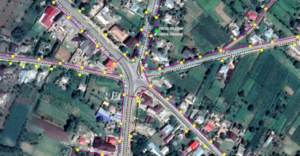
Helmert’s achievement—mapping 18,000 kilometers of low voltage powerlines—demonstrates their expertise in geospatial data management. The Horus LayerManager facilitated precise and efficient data collection.